
lincoln lake - trail #45
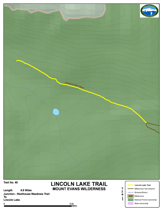
Beginning Elevation: 11440
High Point: 11680
End Elevation: 11680
Difficulty: Easy
Length, One Way: 0.5 mile
Seasons: Summer through Fall
USGS Quads: Harris Park
Other Maps: Arapaho National Forest, Trails Illustrated #104
Usage Level: Medium
Access: The Lincoln Lake Trail has no trailhead, and is accessed via the Resthouse Trail.
Connecting Trails: Resthouse

Description
A short, easy trail, but not easily accessed. The Lincoln Lake Trail provides the varied scenery of an old burn, a bristlecone pine forest, and a timberline lake.
The Lincoln Lake Trail begins at its junction with the Resthouse Trail in the Lincoln Lake burn. The trail goes west through a living forest of Bristlecone pines. The trail fades as you come into view of Lincoln Lake. No fires or camping are permitted at the lake.
TRAIL'S HISTORY
The earliest trail in to Lincoln Lake (also known as Lost Lake) followed along above the edge of timberline from east of Mount Goliath.
The Lincoln Lake trail was probably built in the 1930s. At the time it began at the Echo Lake campground and ended at Lincoln Lake. A map dated November 3, 1933 was likely done in the first year of construction. It shows the trail beginning at the new Echo Lake campground and ending (“Construct. Ends”), about ¼ mile beyond the Vance Creek crossing. Circumstantial evidence indicates it's very likely that this work was done by the CCC from the camp at the present Hells Hole trailhead. It is known they constructed the trail from Echo Lake to the Idaho Springs Reservoir this same year. In the following years, the trail was extended to Lincoln Lake. Sometime after 1945, the section from the Echo Lake trailhead to today’s Lincoln Lake trail was added to the Resthouse trail.
The ghost forest where the trail leaves the Resthouse Trail was created by the 700 acre Lincoln Lake fire in 1968.