
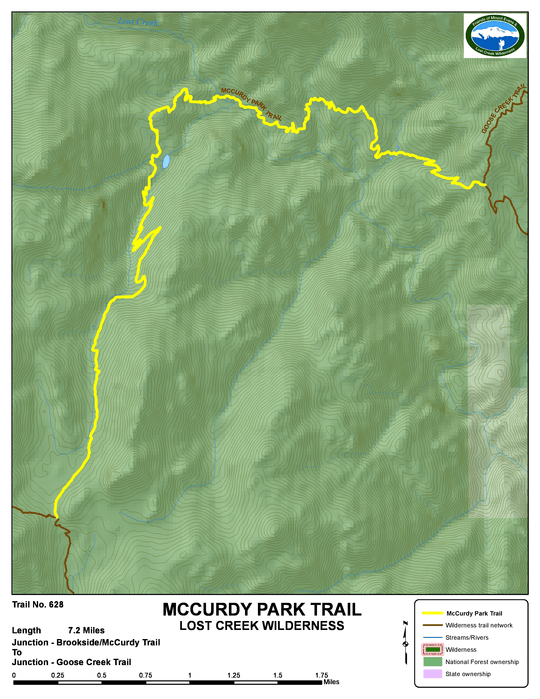
mccurdy park - trail #628
Beginning Elevation: 9420
High Point: 10900
End Elevation: 10900
Difficulty: Difficult
Length, One Way: 7.2 miles
Seasons: Summer, Fall
USGS Quads: McCurdy Mountain
Other Maps: Pike National Forest, Trails Illustrated #105
Usage Level: Medium
Access: This trail has no trailhead access. It is reached only via the Goose Creek or Brookside -McCurdy Trails.
Connecting Trails: Goose Creek, Brookside-McCurdy

Description
One of the most remote trails in the Lost Creek Wilderness, the McCurdy Park Trail traverses some of the more spectacular country in the Wilderness. Near where it crosses Lost Creek, you can see entrances to some of the creek's underground passages, which give it its name. The McCurdy Park Trail is most often hiked as part of a larger loop, which incorporates parts of the Goose Creek, Brookside-McCurdy, Lake Park, and Hankins Pass Trails. Due to the tight rugged terrain, it takes a little time and skill to locate a good legal campsite (at least 100' from streams and trail). Leave yourself a little daylight for the task.
From the north end at its junction with the Goose Creek Trail, the trail drops rapidly down into Refrigerator Gulch, then climbs back out and winds among the granite outcrops before dropping again to Lost Creek. After crossing Lost Creek, the trail climbs over a ridge, then up a side drainage toward McCurdy Park. A long uphill climb brings you at last to McCurdy Park, a high, open valley surrounded by granite crags. To the east is the McCurdy Park Tower, which yields some moderate technical rock climbs. At the south end of the park, the trail meets the Brookside-McCurdy Trail and ends.
TRAIL'S HISTORY
On the east side of the rock outcrop in the middle of McCurdy Park, there once was an A-frame camping shelter, constructed in 1965, by the Forest Service. The last certain date it was standing was in July of 1977. The reason it no longer stands is unknown, but very little evidence remains of it.