
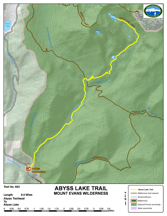
Abyss Lake - Trail # 602

Description
The Abyss Lake Trail is a popular hiking trail that ends at Abyss Lake. The lake is nestled in a high glacial cirque between Mt. Bierstadt and Mt. Blue Sky. The elevation gain, together with the round trip distance of 18 miles makes this a strenuous day hike. The lower portion of the trail is sometimes incorrectly referred to as the "Scott Gomer Trail" because of its location along Scott Gomer Creek.
The first half of the trail heads northeasterly up the Scott Gomer Creek drainage through lodgepole pine forest, and after the third crossing of Scott Gomer Creek you soon reach a trail junction where the Abyss Lake Trail joins the Rosalie Trail. Here the Rosalie Trail runs to the northwest up to Guanella Pass. Note that from here on, the trail may not be located as shown on many maps. For the next short distance you will be on both the Abyss Lake and Rosalie Trails. At the next junction, the Rosalie Trail goes right towards Deer Creek and the Abyss Lake Trail bears left and begins a series of fairly steep switchbacks, bearing again in a northeasterly direction. The trail reaches timberline and enters thick willows southwest of a small unnamed lake. Continue up the valley through the willows until you cross Lake Fork. From this point the trail turns westerly towards the Sawtooth ridge at the head of the cirque. The trail ends at Abyss Lake.
TRAIL'S HISTORY
Early travelers, including Native Americans, followed Scott Gomer Creek up to Guanella Pass and over into the Clear Creek valley. Scott Gomer Creek is named for an early logger in the area. Evidence of his work can be seen occasionally along the trail.
The expansive aspen stands in the valley of Scott Gomer Creek are evidence of a large fire sometime in the past, perhaps the 500+ acre Geneva fire in 1916.
At one time, there was a backcountry campground near the first crossing of Scott Gomer Creek. There was also a three sided shelter house at the Rosalie trail junction until at least 1968. The foundation remains, but the shelter is gone.
In 2006/2007, the trail had minor reroutes due to flooding of the trail by beaver activity. For this reason, the trail may not be exactly as shown on maps.
On July 4, 1969, a single engine Beechcraft Bonanza was caught in the steep walled cirque and, unable to climb out, crashed. Wreckage was visible for many years along the upper section of the trail, below Abyss Lake, until it was hauled out by packstring in late 1996.