
colorado trail - trail #1776

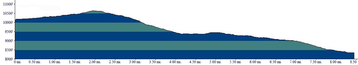
Beginning Elevation: 8360
High Point: 10880
End Elevation: 10140
Difficulty: Moderate
Length, One Way: 23.9 miles
Seasons: Summer, Fall
USGS Quads: Windy Peak, Topaz Mountain
Other Maps: Pike National Forest, Trails Illustrated #105
Usage Level: Medium
Access Trailheads: Rolling Creek, North Fork, Long Gulch, Rock Creek
Connecting Trails: Rolling Creek, Payne Creek, Brookside-McCurdy, Ben Tyler


Description
The Colorado Trail brings the hiker up out of ponderosa pine forests north of the Lost Creek Wilderness through lodgepole pine and Douglas fir forests and into the open parks to the west. The first section of the Colorado Trail closely follows the old Hooper Trail, a logging road built in the late 1800s into North Lost Park. The next part, from the North Fork trailhead to the Long Gulch trailhead, is outside of the Wilderness and is frequently used by mountain bikers as part of a loop ride. The last part continues west through open forests of ponderosa and bristlecone pine to the Rock Creek trailhead.
From the Rolling Creek Trailhead, the Colorado Trail heads west a short distance, then joins the old Hooper Trail logging road and turns southwest. The old logging road that is very distinct and its gentle grade makes for pleasant hiking. A short distance after crossing the Wilderness boundary, the trail meets the south end of the Payne Creek Trail. The Colorado Trail continues rising to the southwest, but before reaching the saddle it leaves the old road and begins to climb rather steeply to the south to avoid some large bogs. At the top of the saddle it rejoins the old road and descends into the North Fork Lost Creek drainage. Upon reaching the creek, the trail joins the Brookside-McCurdy Trail at the North Fork Trailhead. From here the two trails follow the same route up North Lost Park for roughly 2.5 miles. When the two split, the Colorado Trail continues up North Lost Park to its west end and then descends to the Long Gulch Trailhead.
From the Long Gulch trailhead, the trail soon re-enters the Wilderness. It winds west through the gentle country at the head of the Black Canyon, then descends to Rock Creek to a junction with the south end of the Ben Tyler trail. A short climb out of the Rock Creek drainage brings you to the Rock Creek Trailhead.
TRAIL'S HISTORY
The 486 mile Colorado Trail began as an idea in the early to mid 1970s with a plan to build a foot and horse trail from Denver to Durango. By tying together bits and pieces of existing trails, it was hoped that new trail construction could be minimized.
From the east, the Colorado trail follows the old Hooper trail, built by W. W Hooper in 1887 to haul lumber from his mill in North Lost Park to the Railroad at Estabrook, just east of Bailey. A 1898 article in the Nighthawk Mountain Echo expressed concern over the easy access the road would provide into Lost Park and that it would cause the “ruination of the herd of buffalo if a check is not placed on the traffic.” The old road is very boggy just east of the high point and the trail was rerouted around the bogs in the late 1990s. Just east of the North Fork trailhead in North Lost Park lie the remnants of Hooper’s sawmill. The Hooper trail continued west from the North Fork trailhead to the Long Gulch trailhead, although it was not part of Hooper’s original road.
From the Long Gulch trailhead west to Kenosha Pass was all new construction done by volunteers in 1976-77.