
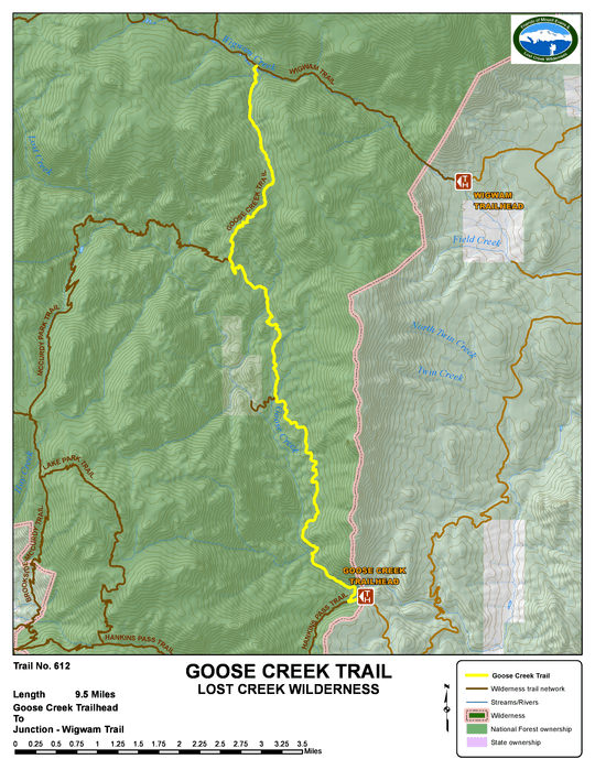
goose creek - trail #612
Beginning Elevation: 8220
High Point: 10140
End Elevation: 9500
Difficulty: Moderate
Length, One Way: 9.5 miles
Seasons: Spring, Summer, Fall
USGS Quads: McCurdy Mountain, Windy Peak
Other Maps: Pike National Forest, Trails Illustrated #105
Usage Level: High, Medium
Access Trail Heads: Goose Creek
Connecting Trails: Hankins Pass, McCurdy Park, Wigwam

DESCRIPTION
The popular Goose Creek Trail provides access into the southeast portion of the Lost Creek Wilderness. The trail winds north and eventually ends in Wigwam Park at a junction with the Wigwam Trail. The Goose Creek Trail offers primitive spectacular views of formations of red Pikes Peak granite. Above the old reservoir site and shafthouse, the creek is Lost Creek, but when it emerges from underground to the south, it is known as Goose Creek.
There are horse corrals near the trailhead that are available for public use. The lower part of the valley is rather tight and good, legal campsites (at least 100' from water and trail) are scarce, so plan to begin hiking from the trailhead early enough to find a good campsite. This area sees heavy use, so do all you can to keep your impact to a minimum.
From the trailhead sign near the parking area, follow the trail a short way down to Hankins Creek and a trail junction. The Hankins Pass Trail heads left (west) and Goose Creek Trail heads right (east). After reaching Goose Creek, the trail follows the creek upstream, crossing over on a large metal footbridge. The valley gradually opens up revealing the domes and spires characteristic of the area.
About 4 miles up the Goose Creek trail, a side trail takes you a short distance west to some old buildings at the Lost Park reservoir site, which date back to the late 1800s/early 1900s. Up to this point, the trail follows the road in to the site. The original owners of the 320 acre reservoir site, Martin, Auls, and Fallette, filed a plat for the site in 1891 and began work damming Lost Creek where it disappeared underground. In 1907, the Lost Park and Antero Reservoir Company acquired the property and continued, without success, to create a reservoir by sealing the underground channel. Denver Water bought out the reservoir company in 1924. In 1931, a final attempt was made to dam the creek, but after spending another $100,000, the effort was abandoned.
TRAIL'S HISTORY
The metal bridge across Goose Creek was built by the Forest Service in 1967-1968. Although the Lost Creek Scenic area had been closed by the Regional Forester to motor vehicles in 1966, permission was granted to transport the bridge and materials by truck.
At about 4 miles up the Goose Creek trail, a side trail takes you a short distance west to some old buildings at the Lost Park reservoir site, which date back to the late 1800s/early 1900s. The original owners of the 320 acre reservoir site, Martin, Auls, and Fallette, filed a plat for the site in 1891 and began work damming Lost Creek where it disappeared underground. In 1907, the Lost Park and Antero Reservoir Company acquired the property and continued, without success, to create a reservoir by sealing the underground channel. Denver Water bought out the reservoir company in 1924. In 1931, a final attempt was made to dam the creek, but after spending another $100,000, the effort was abandoned.
In 2015, Volunteers for Outdoor Colorado did a short reroute about a mile in from the trailhead to take the trail from a badly eroded location near the creek to a better, more gentle location away from the creek on the original road to the shafthouse.